Data Sets
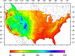
Similar methodology to above, a data set of observed daily and monthly averaged precipitation, maximum and minimum temperature, gridded to a 1/16° (~6km) resolution spanning CONUS and the Canadian portion of the Columbia River Basin, with temporal coverage 1915-201
Read More

A data set of observed daily and monthly averaged precipitation, maximum and minimum temperature, gridded to a 1/16° (~6km) resolution that spans the entire country of Mexico, the conterminous U.S. (CONUS), and regions of Canada south of 53º N for the period 1950-2013.
Read More
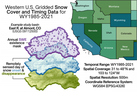
Gridded data is calculated from the UCLA Western U.S. Snow Reanalysis (WUS-SR), which is available at a 16 arc-second (500m) resolution for WY1985-2021 (Fang et al., 2022).
Read More
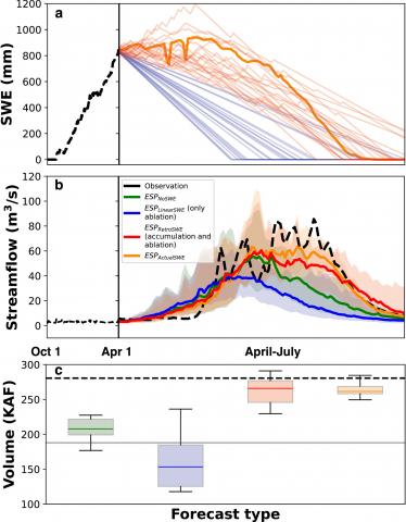
The Ensemble Streamflow Prediction (ESP) framework combines a probabilistic forecast structure with process-based models for water supply predictions. However, process-based models require computationally intensive parameter estimation, increasing uncertainties and limiting usability.
Read More
Information on the 245 burned basins, 293 unburned basins, and 356 associated fires from across the U.S. West which were used in statistical analyses of post-wildfire water quality response.
Read More
A dataset containing the list and shapefiles of basins used in the analysis of intermittency-flooding relationship analyzed in Livneh et al.
Read More
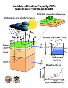
Regional- and continental-scale models predicting variations in the magnitude and timing of streamflow are important tools for forecasting water availability as well as flood inundation extent and associated damages.
Read More
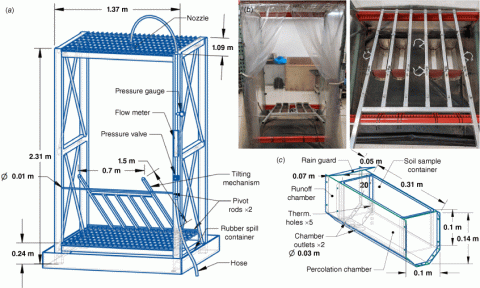
Custom-designed laboratory-scale burn and rain fall simulators were applied to 154 soil samples, measuring subsequent runoff and constituent responses.
Read More
Climate change induced trends in long-term aridity—via changes to atmospheric water demand for have the potential to impact surface water availability across the globe by altering efficiency by which precipitation is converted to runoff.
Read More
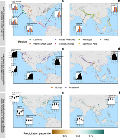
This study evaluates post-wildfire mass movement trigger characteristics by comparing the precipi tation preceding events at both burned and unburned loca tions. Landslide events are selected from the NASA Global Landslide Catalog (GLC).
Read More
Here, a collection of rasters describing annual snow onset (SO), snow cover duration (SCD), and day of snow disappearance (DSD) for WY2001-2019 over Alaska, Canada, and the Western United States (boundary box: -152W, -100W, 32N, 68N) are available.
Read More
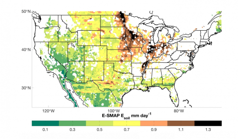
This is an observationally-based dataset of soil evaporation for the conterminous U.S. (CONUS), gridded to a 9 km resolution for the time-period of April 2015-March 2019.
Read More
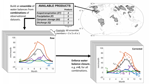
We present a new REmotely Sensed ENsemble of the water cycle (REESEN). The REESEN approach generates a large number of realizations of the remotely sensed water budget and enforces closure for each realization. The REESEN approach is applied to 24 large river basins from Oct. 2002- Dec. 2014.
Read More
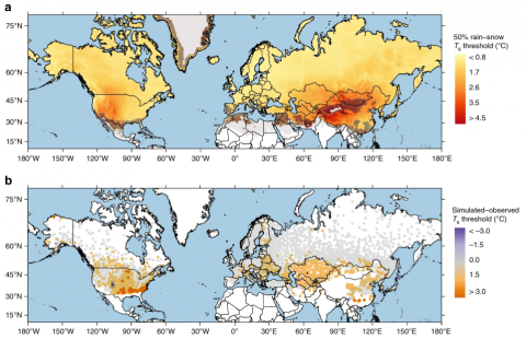
We present the first continuous map of rain-snow air temperature thresholds over the Northern Hemisphere land surface, underlining the spatial variability of precipitation phase partitioning.
Read More
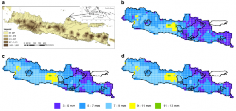
We describe a gridded daily meteorology dataset consisting of precipitation, minimum and maximum temperature over Java Island, Indonesia at 0.125°×0.125° (~14 km) resolution spanning 30 years from 1985–2014.
Read More
Available water supply varies greatly across the United States depending on topography, climate, elevation and geology. Forested and mountainous locations, such as national forests, tend to receive more precipitation than adjacent non-forested or low-lying areas.
Read More