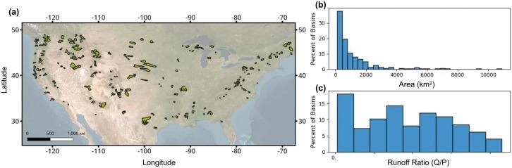
A dataset containing the list and shapefiles of basins used in the analysis of intermittency-flooding relationship analyzed in Livneh et al. 2024 (https://www.sciencedirect.com/science/article/pii/S0048969724039718). 108 watersheds were analyzed, during the period 1950-2022. Basins were filtered from GAGES II dataset using a python script (included in data). Filtering criteria included minimal influence of water management (Hydro Disturbance index <10 and dam storage <10% of mean annual flow) and availability of at least 50 years of daily streamflow and precipitation available.
If you use these data or script, please cite:
Bjarke, N., & LIVNEH, B. (2024). 108 Basins containing a minimum of 50 years of daily discharge and precipitation observations [Data set]. In Science of the Total Environment (1.0). Zenodo. https://doi.org/10.5281/zenodo.10982191