Characterizing the evolution of the 2014 Vulcan Creek landslide-dammed lake, Yukon, Canada – using field and remote survey techniques, led by Marc-André Brideau has been published
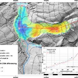
The Vulcan Creek landslide occurred in southwest Yukon in the fall of 2014. No distinct trigger was identified for this landslide; however, contributing factors include the long-term seismicity of the area, 10 °C warmer than normal air temperature in January 2014, and approximately twice the normal rainfall for the month prior to the landslide. Long-term permafrost degradation could have also contributed to the slope instability. The landslide dammed Vulcan Creek, forming a lake with a maximum surface area of ~ 22,000 square meters. The evolution of the lake and overflow channel was characterized using both field observations and satellite imagery. Our observations suggest that while the current configuration the landslide dam is likely stable, the associated hazard to recreational users in the area changes with time as the lake volume varies and the stability of the slope above the lake evolves.