Simulation of Montane Snowpacks for the Preservation of the Wolverine (Gulo gulo luscus) in the Western U.S.
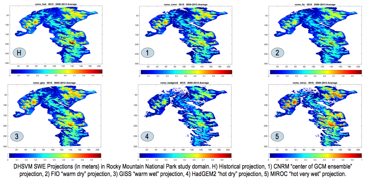
A major gap in research on the future of snowpack in the western United States is accounting for snow persistence in relation to topographical effects like terrain aspect and slope, which have important consequences for species that rely on snow for habitat in alpine regions, such as the wolverine (Gulo gulo). Previous work has shown a predicted loss of snow-covered area in Montana (which encompasses much of the Wolverine’s extent range) ranging from 50 – 85%. However, these estimates use coarse model grid-boxes (6 – 12 km per side) that lack topographic shading, with mean elevations below the higher elevations where the wolverine tends to live. We address these informational gaps by applying a physically-based, high-resolution hydrologic model (250 m spatial resolution), the Distributed Hydrologic Soil and Vegetation Model (DHSVM), to project snow water equivalent (SWE) in two regions important to the survival of the wolverine within Glacier and Rocky Mountain National Parks. Because snowpack evolution is driven primarily by the energy balance at the surface, particularly during melt season, the inclusion of a realistic, physically-based energy balance together with topographic shading enables a clearer understanding of how projected climatic perturbations will affect future snowpack. We apply a diverse sample of future (2035-2064) climate conditions from CMIP5 General Circulation Models (GCMs) to meteorological forcing data from a baseline historical period (1998-2013) through the delta method, after validating historical simulations with SNOTEL and MODIS satellite data. Despite considerable variability across models, the results show a consistent decrease in Snow-Covered Area (SCA) across investigated future climate projections, an increased loss of snowpack during years of drought, and a fragmentation of land with deep snow available for refuge.