
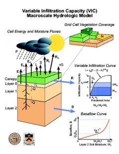
These parameters represent the culmination of numerous calibration efforts including those conducted by Maurer et al. (2002), Zhu et al. (2007) at 1/8° and Tang et al. (2012) at 1/16°, as well as default parameters from the NLDAS initiative for other regions. Information on the VIC model is available here on the University of Washington page.
*Note: Since soil-parameter calibrations were done on a basin-by-basin basis, certain parameters are discontinuous across basin boundaries.
If you use these parameters, please cite:
Livneh B., E.A. Rosenberg, C. Lin, B. Nijssen, V. Mishra, K.M. Andreadis, E.P. Maurer, and D.P. Lettenmaier, 2013: A Long-Term Hydrologically Based Dataset of Land Surface Fluxes and States for the Conterminous United States: Update and Extensions, Journal of Climate, 26, 9384–9392.
Maurer E. P., A.W. Wood, J.C. Adam, D.P. Lettenmaier, and B. Nijssen, 2002: A Long-Term Hydrologically Based Dataset of Land Surface Fluxes and States for the Conterminous United States*. Journal of Climate, 15, 3237–3251.
You may also consider citing:
Zhu, C., T. Cavazos, and D.P. Lettenmaier, 2007: Role of antecedent land surface conditions in warm season precipitation over northwestern Mexico.Journal of climate, 20(9), 1774-1791.
Tang, Q., E.R. Vivoni, F. Muñoz-Arriola, and D.P. Lettenmaier, 2012: Predictability of evapotranspiration patterns using remotely sensed vegetation dynamics during the North American monsoon. Journal of Hydrometeorology,13(1), 103-121.